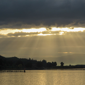
Bradbury Slough
© 2021 by Robert Heacock. Used by permission.
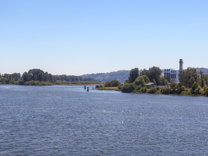
Today, a power plant replaces Winship’s trading post at the upriver end of what Clark called “Fanny’s Bottom” and part of the homelands of the Skilloots.
The Skilloots were an Upper Chinookan group that spoke the Clackamas dialect of the Chinookan language. They were located on both sides of the Columbia River above and below the mouth of the Cowlitz. At first, the captains applied the name over a much wider area, perhaps misinterpreting a similar Chinookan expression meaning ‘look at him!’. Cape Horn, a few miles east of Washougal, was named sqúlips, and could be the origin of the tribe’s name.[1]Michael Silverstein, Handbook of North American Indians: Northwest Coast Vol. 7, ed. Wayne Suttles (Washington, D.C.: Smithsonian Institution, 1990), 545. Note that the upper Cape Horn is named here, … Continue reading In 1806, captains estimated the people’s population to be 2500 souls.[2]Moulton, Journals, 6:484.
The Winship Expedition
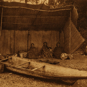
On 26 May 1810, the storied ship Albatross captained by Nathan Winship and first-mate William Smith crossed the Columbia River bar intent on being the first to establish a trading post in what would become the Oregon territory. Up the river, past Lewis and Clark’s dismal nitches, the party anchored their big ship, and continued up the river to a summer village site of the Skilloot called qániak, Conniac or Konnaack. They had with them twenty-five Kanakas, Hawaiian laborers, a practice successfully employed by the Hudson’s Bay Company at Cowlitz Farm and Fort Vancouver. An extensive bottom on the south side of the Columbia displayed the first oak trees they had seen since entering the river, so they named the cliff at the upper end Oak Point. On 26 March 1806, Captain Lewis and Captain Clark had named the flat Fanny’s Bottom.[3]Oak Point was the commonly used name at least through the Wilkes Expedition of 1841. It is presently known as Port Westward and not to be confused with several other Oak Points on the lower Columbia. … Continue reading
When the Winship party’s main building had been raised to a height of ten feet and their crops planted, the Columbia River flooded the site forcing them to float their logs down the river and build on higher ground. The watchful Chinook were not pleased with the trader’s choice of location and told them that the Chinook people’s traditional role as intermediaries was being ignored. Both sides were called to arms and Captain Winship came to understand that the post could not be defended once the Albatross left the river. After just three weeks in existence, the trading post was abandoned. When the ship returned the next year, William Smith was now at the helm, and he discovered that the presence of Astor Company’s Fort Astoria signaled the end the Winship Brothers’ plans on the Columbia.[4]Hubert Howe Bancroft, History of the Northwest Coast, vol. 2 1800–1846 in The Works of Hubert Howe Bancroft, vol. 28 (San Francisco: A. L. Bancroft, 1884), 129–135. See especially the excerpt … Continue reading
Final Years at Oak Point
The Konnaack Skilloot would never become significant traders and in 1851, Skilloots on both sides of the river ceded their lands in a treaty negotiated by Superintendent of Indian Affairs for Oregon Territory, Anson Dart. In return, they were given gifts and allowed to live and hunt on their traditional lands at Oak Point.[5]Robert H. Ruby, John A. Brown, and Cary C. Collins, A Guide to the Indian Tribes of the Pacific Northwest (Norman: University of Oklahoma Press, 2010), 295.
Selected Pages and Encounters
November 6, 1805
Among the Cowlitz People
Little Cape Horn, WA The night is rainy and during the day, the men paddle in the rain past villages at the mouth of the Cowlitz. They buy salmon and wapato and are told that Captain Haley visits the mouth of the Columbia. At camp, they build large fires to dry out and kill the fleas infesting their blankets.
December 31, 1805
New latrine and sentry box
Fort Clatsop, Astoria, OR An Indian musket is repaired, and a red-headed Clatsop is among the many Indians visiting today. A latrine and sentry box is constructed, and Clark notices that the visiting Indians are behaving better.
January 13, 1806
Running out of candles
Fort Clatsop, Astoria, OR Elk tallow is rendered to make new candles, Lewis finds that the area’s elk do not have enough fat to make a sufficient supply, and President Jefferson writes to Lewis’s mother with news of the expedition’s progress.
January 14, 1806
The Columbia River fishery
Fort Clatsop, Astoria, OR The captains estimate that the Columbia River fishery produces 30,000 pounds of salmon for market each year. Another canoe goes adrift and must be found.
January 20, 1806
Five new plant specimens
Fort Clatsop, OR Lewis prepares five new plant specimens and describes roots eaten by local Indians. The captains worry about the rate at which they are going through their supply of elk meat.
January 30, 1806
Chinookan lifeways
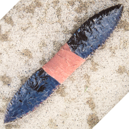
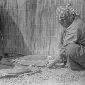
Fort Clatsop, Astoria, OR Lewis says that nothing worthy of notice happens on this day. He describes Chinookan lifeways including, dress, hats, and double-edge knives.
March 25, 1806
Downstreamer Chinooks
As they paddle along the south shore of the Columbia, the expedition sees Downstreamer Chinooks trolling for sturgeon. After fifteen miles, they find a popular camping spot at the present Clatskanie River.
March 26, 1806
At Fanny's Bottom
After a wet night, they paddle approximately 18 miles up the Columbia River and camp on an island near an area they call “fannys bottom”. Lewis describes eagles and substitutes for tobacco.
March 27, 1806
Generous Skilloots
Near present Deer Island, Oregon, some generous Skilloots give away food with hopes that the expedition hunters will hunt with them. Lewis describes the area’s trees and prepares a salmonberry specimen.
April 16, 1806
"Great Mart of all this Country"
Clark crosses the river to trade for horses and calls The Dalles of the Columbia the “Great Mart of all this Country.” At Fort Rock, the men make saddles, Lewis botanizes, and Cruzatte plays the fiddle.
Notes
| ↑1 | Michael Silverstein, Handbook of North American Indians: Northwest Coast Vol. 7, ed. Wayne Suttles (Washington, D.C.: Smithsonian Institution, 1990), 545. Note that the upper Cape Horn is named here, not the one downriver from the mouth of the Cowlitz. See Henry B. Zenk, Yvonne P. Hajda, and Robert T. Boyd, “Chinookan Villages of the Lower Columbia,” Oregon Historical Quarterly, 2016, Vol. 117, No. 1, 32. |
|---|---|
| ↑2 | Moulton, Journals, 6:484. |
| ↑3 | Oak Point was the commonly used name at least through the Wilkes Expedition of 1841. It is presently known as Port Westward and not to be confused with several other Oak Points on the lower Columbia. The village was located immediately across from the western end of Crims Island, the expedition’s Fanny’s Island. Lewis A. McArthur, Oregon Geographic Names, 4th Edition, revised and enlarged by Lewis L. McArthur (Portland, Oregon Historical Society, 1974), 547; The Manuscript Journals of Alexander Henry and of David Thompson, ed. Elliott Coues (London: Suckling & Company, 18987), 795. |
| ↑4 | Hubert Howe Bancroft, History of the Northwest Coast, vol. 2 1800–1846 in The Works of Hubert Howe Bancroft, vol. 28 (San Francisco: A. L. Bancroft, 1884), 129–135. See especially the excerpt from the journal of William A. Gale, captain’s assistant, note 13 starting on page 133. The Winships and Captain Smith, as well as their ships the Albatross and O’Cain would successfully trade for several years throughout the Pacific, including California, Hawaii, and China. |
| ↑5 | Robert H. Ruby, John A. Brown, and Cary C. Collins, A Guide to the Indian Tribes of the Pacific Northwest (Norman: University of Oklahoma Press, 2010), 295. |