Clark and Lewis remain another day at the Falls of the Ohio likely anxious to set out. For millennia, the American buffalo crossed the river here, and the roads these foraging mammals engineered connected the region’s meadows and salt-producing springs in a vast network followed by Native Americans, Western pioneers, and Lewis and Clark in 1806.
The Buffalo’s Prodigious Roads
Blue Licks, Kentucky
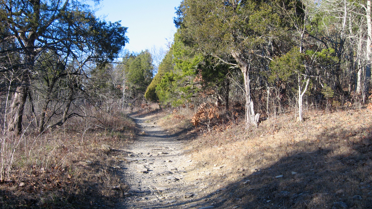
By Mason Brock who has released it to the Public Domain.
An ancient animal/human trail leads though eastern redcedar (Juniperus virginiana) at Blue Licks, Kentucky. Here, two springs supplied settlers with salt and other medicinal minerals and attracted game. In this way, saline springs helped determine the location of settlement throughout the Ohio river region. One of the last battles of the Revolutionary War, the Battle of Blue Licks on 19 August 1782, involved William’s older brother George Rogers Clark and Daniel Boone.
The amazing herds of Buffaloes which resort thither, by their size and number, fill the traveller with amazement and terror, especially when he beholds the prodigious roads they have made from all quarters, as if leading to some populous city . . . .
—John Filson, 1784[1]John Filson, The Discovery, Settlement and Present State of Kentucke (1784): An Online Electronic Text Edition, ed. Paul Royster (Lincoln: University of Nebraska), 24, … Continue reading
Taking the High Ground
As part of his “Historic Highways of America” series, Archer Butler Hulbert described how the buffalo created the trails followed in the “Conquest of the Old Northwest” by George Rogers Clark during the Revolutionary War.
The old paths of the buffalo, long known as hunting traces, offered the traveler from the Ohio to the old-time metropolis of Illinois a short-cut by land, saving thrice the distance by water, and obviated stemming the swift tides of the Mississippi. One of the principal backbones of Illinois was threaded by these primeval routes, and high ground between the vast cypress swamps and mist-crowned drowned lands of Illinois was a boon to any traveler, especially that first traveler, the bison. This high ground ran between Kaskaskia and Shawneetown, on the Ohio River, the course becoming later a famous state highway. Its earliest name was the “Kaskaskia Trace.”[2]Archer Butler Hulbert, Historic Highways of America: Military Highways of America (Cleveland, Ohio: The Aurthur H. Clark Company, 1904), 8:16–17, Project Gutenberg ebook, … Continue reading
Sacagawea Shows the Way
On his way to the Yellowstone River, Clark was mired in beaver ponds and swamps in the Gallatin River valley. Sacagawea told him of a better way—a buffalo trace—that avoided these low areas.
Swamped as I may Say in this bottom of beaver I was compelled to turn Short . . . . the Squar informed me that there was a large road passing through the upper part of this low plain from Madicins river through the gap which I was Stearing my Course to . . . . Struck an old buffalow road [Nicholas Biddle: the one our Indn woman meant] which I kept
—William Clark, 14 July 1806
Along the Wilderness Road
Returning to Washington City late fall of 1806, Lewis, and the Mandan delegation traveled from the Falls of the Ohio to the Piedmont of Virginia along pathways engineered by the American buffalo:
Kentucky’s Wilderness Road through Cumberland Gap to Louisville followed a series of buffalo traces . . . . Indeed, travelers in the nineteenth century leaving the Big Lick near Roanoke, Virginia, could travel over a thousand miles to the Grand Prairie of Illinois without leaving roads originally derived from buffalo traces.[3]John A. Jakie, Images of the Ohio Valley, A Historical Geography of Travel, 1740 to 1860 (New York: Oxford University Press, 1977), 57–58, available at … Continue reading
Experience the Lewis and Clark Trail
The Lewis and Clark Trail Experience—our sister site at lewisandclark.travel—connects the world to people and places on the Lewis and Clark Trail.
Plan a trip related to October 23, 1803:
Notes
| ↑1 | John Filson, The Discovery, Settlement and Present State of Kentucke (1784): An Online Electronic Text Edition, ed. Paul Royster (Lincoln: University of Nebraska), 24, digitalcommons.unl.edu/etas/3?utm_source=digitalcommons.unl.edu%2Fetas%2F3&utm_medium=PDF&utm_campaign=PDFCoverPages. |
|---|---|
| ↑2 | Archer Butler Hulbert, Historic Highways of America: Military Highways of America (Cleveland, Ohio: The Aurthur H. Clark Company, 1904), 8:16–17, Project Gutenberg ebook, www.mirrorservice.org/sites/ftp.ibiblio.org/pub/docs/books/gutenberg/4/1/1/6/41167/41167-h/41167-h.htm. |
| ↑3 | John A. Jakie, Images of the Ohio Valley, A Historical Geography of Travel, 1740 to 1860 (New York: Oxford University Press, 1977), 57–58, available at archive.org/details/imagesofohiovall0000jakl_w0q3. |